How marine seismic is done
Six ways of listening to the ground under the sea, and what happens to the recordings afterwards, in plain English, by people who have stood on the back deck.
- The short version
- Nodes by ROV
- Node on rope
- High-resolution 3D
- Towed streamer
- 4D
- Site surveys
- Processing
- Interpretation
The short version
All seismic, in a paragraph or three
Every marine seismic survey does the same simple thing. A source near the surface makes a short, loud sound. The sound travels down into the rock, bounces off the layers, and comes back up. Receivers record the echoes. Do that millions of times, from millions of positions, and a processing team can build a picture of what lies kilometres under the seabed.
What differs between the methods is the arrangement. Where the receivers are: towed behind a ship near the surface, or sitting on the seabed. How they are laid out: how far apart, in what pattern, over how wide an area. And what the source is: its size and the sound it makes, its signature, chosen for the target. A big, low-pitched source to reach rock kilometres down; a small, high-pitched one to see the first few metres in fine detail. You cannot have both in one shot, because the low notes travel deep and the high notes give the detail.
Those choices decide the cost, the speed, the water depth you can work in, how close you can get to platforms and pipes, and how good the picture is.
A word about the sound itself. No source makes a clean, perfect click. A marine source goes bang, then rings, then bubbles, a little like a struck bell that also hiccups. That shape is the source's signature, its fingerprint, and it is different for every source and every setting.
The signature matters because of what you are actually measuring. You send a sound down; an echo comes back. The echo is the signature after the rock has had its way with it: delayed, weakened, bent, broken into pieces by every layer it met. What you want is the difference between the two, the delta between the sound that went down and the sound that came back. That difference is the rock.
And what goes down is not left to chance. The source is tuned: the sizes of the guns, how deep they hang, how they are spaced and fired, all chosen to put out the frequencies the job needs, low ones to reach deep rock, high ones for fine detail, and to keep the bubbling down. The rock decides what comes back, but you decide what goes down, and you can only learn about the rock in the notes you actually sent. Leave a frequency out of the source and no amount of clever processing will find it in the return.
So the signature is recorded, shot by shot, close to the source. Know exactly what went down, and processing can take it out of what came back, leaving the earth's own answer, sharp enough that thin layers stay thin instead of smearing together. Guess what went down, and you are looking at the source as much as the rock.
Everything else, the vessels, the crews, the weeks of weather standby, is logistics in service of those choices. Which is to say, most of the job.
And underneath all of it is one humble idea. A shot point, a node position, the spot where a cone was pushed into the seabed: each is a place, at a time, with something measured there. Every method on this page is a way of collecting those points.
In seismic, the place and the time are not paperwork; they are the measurement. The whole picture is built from how long the sound took to travel from one known place to another. Get a position wrong by a few metres, or a clock wrong by a few milliseconds, and the rock in the picture moves. Worse, it moves quietly. A recording from the wrong place still looks like a perfectly good recording; wrong looks exactly like right, until a well comes in somewhere it shouldn't. So both have to be known to a very high degree of accuracy, and checked, not assumed. That is why a node carries a better clock than most wristwatches, why every shot is stamped to the millisecond, and why positioning crews are never quite as relaxed as everyone else.
Ocean-bottom nodes, laid by ROV
Deep water, crowded fields, the best picture money buys
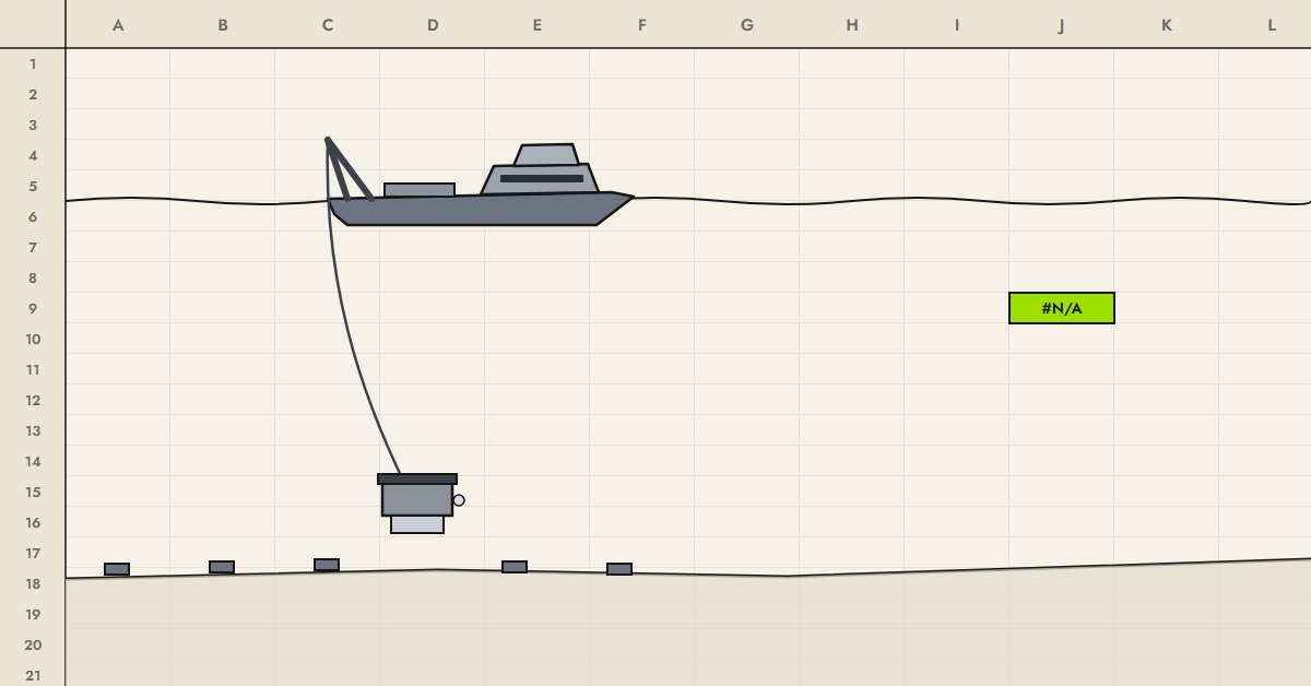
A node is a self-contained recorder about the size of a cake tin, sometimes a large one. Inside: a hydrophone for pressure, three motion sensors for the ground's movement in every direction, a very accurate clock, and a battery. It has no cable. It sits on the seabed and records everything, all the time, until someone comes to fetch it.
In deep water the nodes are placed one by one by a remotely operated vehicle, an ROV, working from a support vessel. The ROV carries a basket of nodes down, sets each one on its planned position, goes back up for more, and repeats. Weeks later it collects them again. Meanwhile a separate source vessel sails back and forth above, firing.
Because the receivers are on the seabed and the source is free to roam, you can record sound arriving from every direction and over long distances, and you can work right up to platforms and pipelines that a towed spread has to steer around. The picture is usually the best available. So is the price.
There is a quieter reason it looks so good, too. A node is not hanging in the water column. It sits still on the seabed, a long way from the noise at the surface: no swell, no waves slapping a cable, no hum of being dragged along behind a ship. The recording is quieter, so the faint echoes from deep rock stand out. In the trade's words, the signal-to-noise ratio is much better.
The catch: a node tells you nothing until it comes back. You find out whether it worked, and whether its battery lasted, only when it is on deck again. Planning for that is half the art.
- Water depth
- From a few tens of metres to several kilometres
- Strengths
- All-direction recording, quiet seabed recording, works round infrastructure, very repeatable
- Weaknesses
- Slow, expensive, blind until recovery
Node on rope
The same nodes, laid like a fishing line
Same idea, faster method. Instead of an ROV placing each node by hand, the nodes are clipped to a rope at set spacing and paid out over the stern as the vessel sails. To recover them, the rope is winched back aboard and the nodes unclipped.
It is much quicker and cheaper than ROV work, and it suits shallower water and open seabed. The price is precision: a rope settles where the sea and the seabed let it, not exactly where the plan said, and it cannot weave neatly between obstructions. Each node's true position has to be measured after it lands.
- Water depth
- Shallow to moderate
- Strengths
- Fast, cheaper than ROV, still seabed recording
- Weaknesses
- Less precise placement, awkward around obstructions
High-resolution 3D
A small, sharp spread for the shallow ground
Shrink a streamer survey and point it at the first few hundred metres instead of the first few kilometres. Instead of a handful of long cables, a small vessel tows a great many short ones, often tens of metres each, hung side by side from a cable stretched across behind the stern and held open by floats either side. The source is small and high-pitched to match: high notes carry the detail.
The result is a three-dimensional picture of the shallow ground in remarkable detail, gathered quickly and cheaply by a vessel that can work close in. It is used where the near-surface matters: shallow gas and other drilling hazards, foundations for wind farms, and watching over places where carbon dioxide is stored underground. It will not see the deep reservoir. It is not trying to.
- Looks at
- The first few hundred metres, in fine detail
- Strengths
- Very high resolution, small vessel, quick and economical
- Weaknesses
- Shallow only; weather-sensitive, as small boats are
Towed streamer
The workhorse of marine 3D
A single vessel tows everything. Behind it, the source, and behind that, a spread of long cables called streamers, each several kilometres long and full of hydrophones, held a few metres under the surface and spread wide like a fan. The vessel sails straight lines over the area, turns, and comes back on the next line.
It covers ground fast and is by far the most common way to shoot a marine survey. The limits come from towing a spread several kilometres long and wide: it turns slowly, it cannot get close to platforms, and the currents push the cables sideways, which the crew spends a good part of the day correcting. It mostly records sound arriving along the direction of sailing, though several vessels working together can widen that.
- Water depth
- Anything deep enough to tow in safely
- Strengths
- Fast, efficient, huge areas
- Weaknesses
- Keeps its distance from infrastructure, limited directions, at the mercy of currents
4D, or time-lapse
The same survey again, years later, to watch the reservoir change
Shoot a field before production, shoot it again a few years later, and subtract one from the other. What is left shows where the oil, gas or injected water has moved. That is 4D: three dimensions, plus time.
The difficulty is that the difference you are looking for is small, so everything else has to stay the same: the source in the same places, the receivers in the same places, the same equipment settings, as near as humanly possible. Repeatability is the whole game, which is why seabed receivers, and the careful records of exactly where everything was last time, matter so much.
- Used for
- Managing producing fields: where to drill next, what is being left behind
- The hard part
- Doing it exactly the same way twice, years apart
Site surveys and geotechnical work
The first few hundred metres, before anything is built
Before a platform, a pipeline, a wind turbine or a drilling rig goes in, somebody has to know what the seabed and the ground just below it are like. Site surveys answer that, with smaller, sharper tools than deep seismic: high-resolution seismic for the shallow layers, sonar and multibeam for the seabed itself, magnetometers for anything metal lying about.
Geotechnical work is the hands-on half, where engineers stop listening to the ground and start poking it.
- CPT
- Cone penetration testing: a narrow cone pushed steadily into the seabed while it measures the resistance at its tip, the friction along its side and the water pressure in the ground. Metre by metre, a profile of how strong the soil is.
- Cores
- Tubes driven into the seabed (by vibration, weight, or a piston) and pulled back up full, so the actual sediment can go to a laboratory.
- Boreholes
- Drilled from a specialist vessel, with samples and tests taken at depth, for the places where the structure will push hardest.
- Grabs
- A bucket on a wire for a quick sample of the surface. Unglamorous, and often the first thing anyone knows about the seabed.
The geophysics says where to look; the geotechnics says what is there, and the two are interpreted together. Hazards such as pockets of shallow gas, boulders or old debris are cheap to find this way and very expensive to find by accident.
- Used for
- Foundations, pipeline routes, wind farms, drilling hazards
- Scale
- The seabed to a few hundred metres down, in very fine detail
Processing
From millions of recordings to one picture
What comes off a survey is not a picture. It is millions of recordings, each one a wiggly line of sound against time, tagged with where the source was, where the receiver was, and when. Processing is the long job of turning that into an image of the rock.
Roughly, in order: every recording is matched to its exact place and time (if those are wrong, see above, nothing after this will save it). Noise is removed: swell, other vessels, the crew's own machinery. The source's fingerprint is taken out, using the signature recorded at the time. Echoes that bounced around between the seabed and the surface more than once, which the trade calls multiples, are stripped out so they are not mistaken for real layers. The speed of sound through the rock is worked out, layer by layer, because without it you cannot tell how deep anything is. Then, in a step called migration, every echo is moved back to the place underground it actually came from, and millions of them are added together into one picture.
It used to happen mostly ashore, months after the last shot, with a small team on the vessel doing a rough first pass to check nothing was going wrong. That is changing. Satellite internet at sea is now quick enough to send large amounts of data ashore while the survey is still running, so more of the work, and more of the checking, is done on land as the data arrives. Fewer people need to be offshore to do it, problems are spotted sooner, and the first usable images arrive weeks earlier than they did.
- Takes
- Traditionally months; getting shorter
- The hard parts
- Removing what isn't rock without removing what is; getting the speed of sound right
Interpretation
Reading the picture, and deciding what to do about it
The processed image goes to geologists and geophysicists, who read it. They trace the layers, find the faults that break them, and look for the places where the rock might hold oil, gas, or room to store carbon dioxide. They look at how strongly each layer echoed, which can hint at what fills the rock. On a 4D job, they compare this year's picture with the last and watch the fluids move.
The honest bit: the picture is not a photograph. It is a model built from echoes, with every assumption along the way baked into it, and two good interpreters can read the same image differently. That is not a flaw in the people; it is the nature of looking at rock you will never see through kilometres of other rock. The best interpretations say what is known, what is guessed, and how confident anyone should be. The decisions that follow, where to drill and how much to spend, are some of the biggest in the industry, which is why everything upstream of them, the positions, the clocks, the source, the processing, has to be right.
- Produces
- Maps of the layers, faults and likely reservoirs; where to drill next
- The honest part
- It is a model with uncertainty, not a photograph